Understanding the tourist map of Cabo San Lucas is one of the most important steps when planning your trip. Cabo may look small on a map, but the experience you have depends heavily on where you stay, what is nearby, and how the city is laid out.
This guide explains Cabo (Mexico) clearly and simply. You will learn how the city is organised, what each area offers, how far places are from each other, Cabo vacation villa rentals, and how to use a Cabo San Lucas map to plan a smoother, more enjoyable stay.
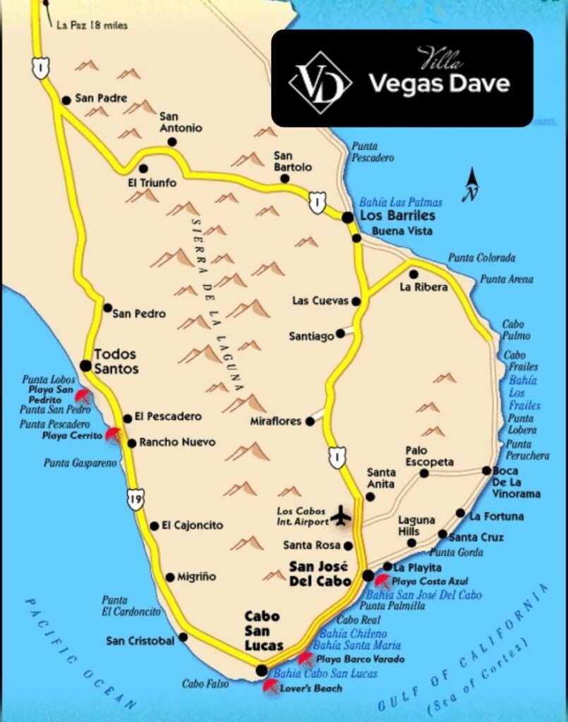
Understanding the Location of Cabo
Cabo San Lucas sits at the southern tip of the Baja California Peninsula. The city is built around its marina, beaches, and surrounding hills. On most Cabo San Lucas tourist maps, you will notice that the city is divided into clear zones rather than one large walkable area.
The main areas include:
- The downtown and marina district
- Beachfront resort zones
- Hillside residential communities
- The Tourist Corridor that connects Cabo San Lucas with San José del Cabo
Knowing this layout helps tourists avoid common mistakes, such as booking accommodation far from planned activities or underestimating travel time.
Downtown Cabo San Lucas: The City Centre on the Map
Downtown Cabo San Lucas is where many visitors first arrive and explore. This area is compact, lively, and easy to walk.
Downtown includes local shops, restaurants, bars, pharmacies, and casual dining spots. Many nightlife venues and popular streets are located here, making it ideal for travellers who want to experience the energy of the city without relying on transport.
On a tourist map of Cabo San Lucas, downtown appears close to the marina and within short walking distance of many attractions. It is best suited for first-time visitors, short stays, and travellers who enjoy being in the centre of activity.
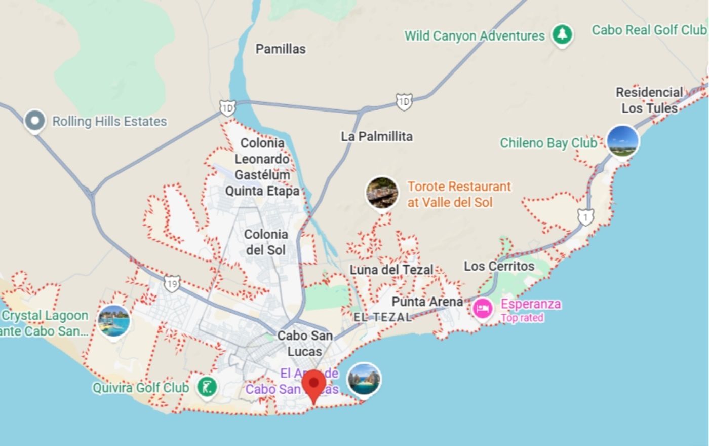
Cabo Marina Area: The Heart of Tourist Activity
The Marina Cabo San Lucas is one of the most important points on map for tourists. This is where the city meets the sea.
The marina is where most boat tours depart, including whale watching, sunset cruises, fishing charters, and trips to famous landmarks. Restaurants line the water, offering views of yachts and the harbour throughout the day and evening.
Because of its central location, the marina connects easily with downtown and nearby beaches. Tourists who plan excursions often prefer staying close to this area, as it reduces travel time and makes daily planning easier.
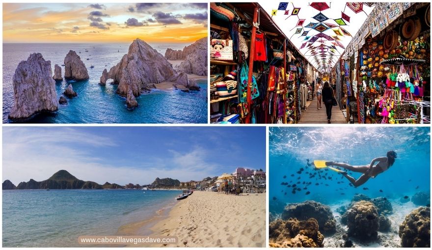
Médano Beach Area: Swimmable Beach Zone
Medano Beach is the most popular swimmable beach in Cabo. It is one of the few beaches in the area where swimming is generally safe, which is why it appears clearly marked on tourist maps.
This area combines beach access with resorts, restaurants, beach clubs, and water sports. Visitors can walk between their accommodation, the beach, and nearby dining spots, making it especially appealing for families and relaxed beach-focused trips.
On a Cabo San Lucas tourist map, Medano Beach sits just east of the marina and close to downtown, offering a balance between activity and comfort.

Pedregal: Hillside Luxury and Privacy
Pedregal is a gated hillside community located just above downtown Cabo San Lucas. While it appears very close on the map, it offers a completely different experience from the busy city centre.
Pedregal is known for its private villas, ocean views, quiet streets, and elevated location. It is not a walkable area due to steep roads, but short drives connect it easily to the marina, downtown, and beaches.
Many travellers choose Pedregal when they want privacy, space, and a more exclusive environment while still staying close to Cabo’s main attractions.
Staying in Pedregal: A Natural Choice for Villa Guests
For travellers who prefer space and comfort over hotel crowds, Pedregal stands out clearly on the tourist map of Cabo San Lucas. This is where many luxurious villas like VillaVegasDave 2 are located, offering a different way to experience Cabo.
Villas in this area allow guests to enjoy ocean views, private pools, and quiet surroundings while remaining just minutes from the marina and downtown. This setup works especially well for families, groups, and travellers celebrating special occasions who want both privacy and convenience.

Choosing a villa here means your map-based planning becomes simpler. You stay close to major attractions while returning each day to a peaceful setting away from busy tourist streets
The Tourist Corridor: Resort-Focused Travel Zone
The Tourist Corridor stretches along the coast between San José del Cabo and Cabo San Lucas. On a Cabo San Lucas map, this appears as a long coastal strip rather than a central area.
This zone is home to large resorts, golf courses, and secluded beaches. It is designed for guests who plan to spend most of their time within resort grounds. Transport is required for dining, shopping, or visiting attractions.
The Tourist Corridor is best suited for relaxed, resort-based holidays rather than active sightseeing trips.
Key Attractions Marked on a Cabo San Lucas Tourist Map
Most tourist maps highlight iconic landmarks such as:
- El Arco
- Land’s End
- Medano Beach
- Marina departure points
These landmarks are often accessed by boat, which is why marina locations matter when reading the map.
Walkable and Drive-Only Areas Explained
One of the most important details a tourist map shows is walkability. Downtown, the marina, and Medano Beach are easy to explore on foot. Hillside areas like Pedregal and the Tourist Corridor require transport.
Understanding this difference helps visitors avoid booking accommodation that feels inconvenient for their travel plans.
How to Use a Cabo San Lucas Map for Better Trip Planning
A well-read tourist map helps you group nearby activities, reduce travel time, and choose accommodation that matches your goals. It also prevents overbooking tours far apart or underestimating distances between areas.
When you understand the map, Cabo becomes easy to navigate and far more enjoyable.
Summary
A tourist map of Cabo San Lucas helps you understand where to stay, how to get around, and which areas fit your travel style. When you plan around the map, your trip feels easier and more relaxed.
If you prefer space, privacy, and a central location close to the marina and beaches, choosing a private oceanfront villa in Cabo San Lucas allows you to enjoy with comfort and clarity from the start.